Dive Trips · Playas del Coco
The Dive Maps of Costa Rica
We dive three very different worlds out of Playas del Coco — the everyday reefs of the Gulf de Papagayo, the manta grounds of the Catalinas, and the bull sharks of the Bat Islands. Here are our Costa Rica dive maps, one for each area, plus a straight-up look at what you'll find there.
Three areas, one fast fleet
Local reefs are minutes away; the islands are a short, fast boat ride. Pick your adventure — or string all three together.
The diving here breaks down into three groups: our local sites in the Gulf de Papagayo, the Catalina Islands to the south, and the Bat Islands up at the edge of Santa Rosa National Park. Each has its own character, its own best season, and its own cast of animals. Have a look at the maps below, then dig into the detail pages for whichever one has your name on it — and get in touch with any questions.
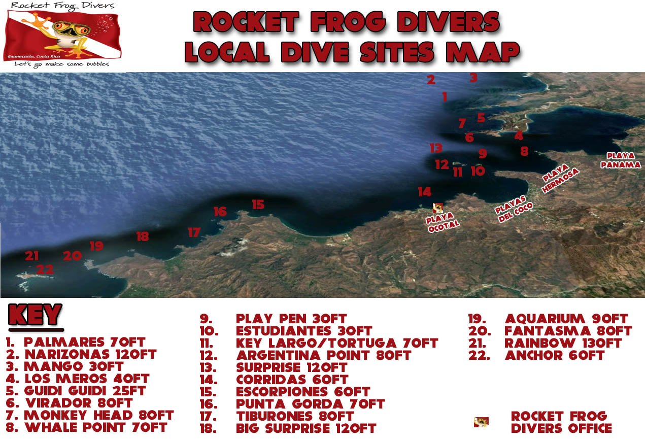
Local Diving Map — Gulf de Papagayo
Our home water starts just a 15-minute boat ride from the dock. Around 30 named sites are scattered across the Gulf de Papagayo — sandy macro flats, rocky reefs, and pinnacles thick with fish. This is where most divers spend day one: calm, forgiving, and absolutely full of life. Regulars include Tortuga, Argentina Point, Sorpresa, Monkey Head, Turning Point, Shark Shallows, Punta Gorda, the Aquarium and Palmares.
Expect turtles, octopus, eels, white-tip reef sharks and clouds of fish — plus some of the best macro on the coast for those who slow down and look: seahorses, frogfish and nudibranchs. Conditions shift daily. Visibility runs roughly 10 to 70 feet, thermoclines come and go, and a 3mm wetsuit does the job year-round. It's the ideal place to learn, to warm up, or just to rack up an easy, beautiful dive.
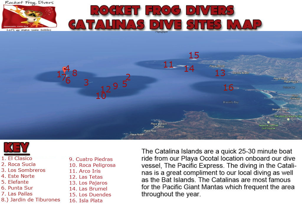
Catalinas Islands Dive Map
About a half-hour south of Coco, the Catalina Islands are your best shot at the Pacific Giant Manta — a ray with a wingspan wider than a car is long, and around for most of the year. The islands rise from deeper water, so big schools of fish and rays gather here alongside turtles and the occasional something-special: whale sharks, orcas, humpbacks and dolphins all pass through in season.
Visibility is at its best from May through mid-November. The Catalinas suit a wide range of divers, and on the right day, watching a manta bank overhead is the kind of dive people plan a whole trip around.
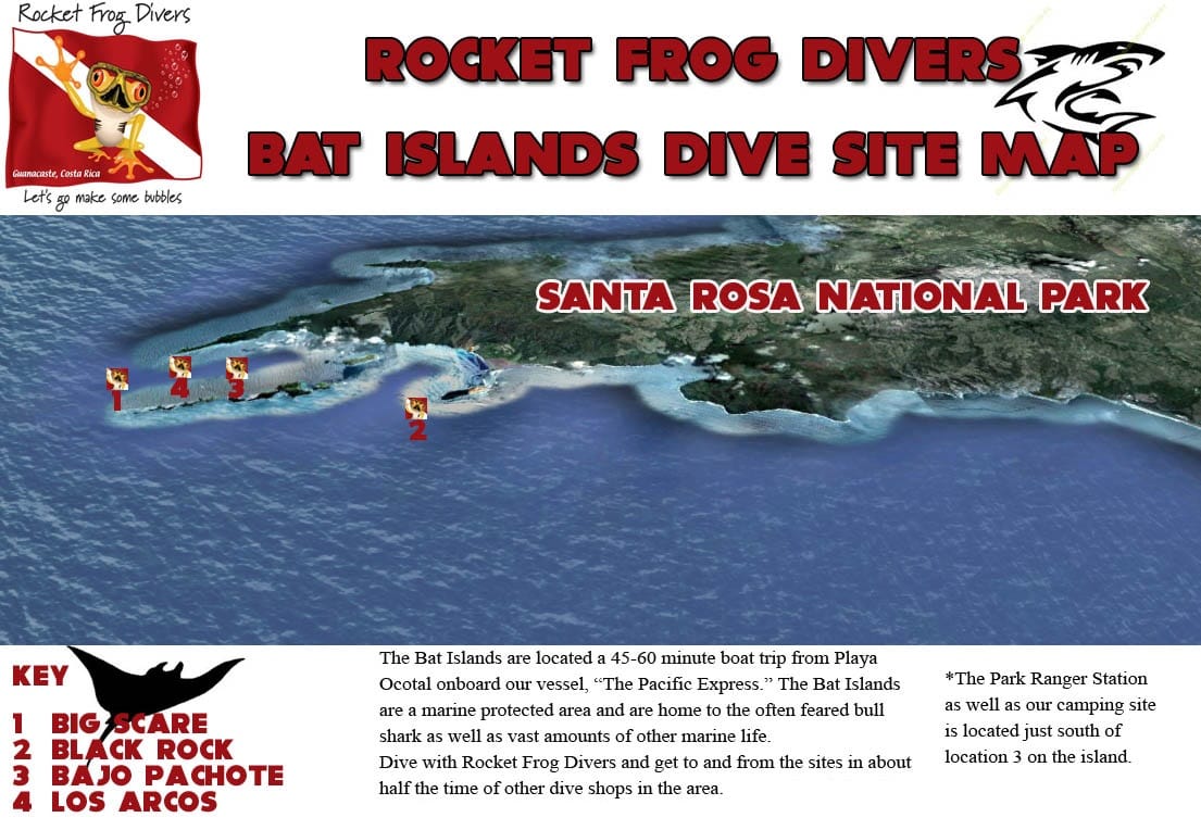
Bat Islands Dive Map — Islas Murciélago
The Bat Islands are a roughly 50-minute run to the edge of Santa Rosa National Park, and they're the reason a lot of divers fly to Costa Rica in the first place. This is one of the only places in the country to dive with bull sharks — big, powerful animals, up close in the blue at a site called the Big Scare. It's advanced diving: the water's deep, the currents are strong, and we often drop in on a negative descent.
The whole area is a protected marine reserve, so the life out here is staggering — schools of devil rays that can number in the thousands, mantas, turtles, eels and rays. The crossing is best from May to November; in the windy dry-season months it's often too rough to attempt, so those days shift to the Catalinas and local sites.
Ready to make some bubbles?
Not sure which trip is right for you? Tell us your dates and experience level and we'll point you to the perfect day — or all three. Fruit, snacks and a fast boat come standard.
Book your Costa Rica dive with Rocket Frog Divers →